 |
Construction on the Kawailoa Trail was started in March of 1934 and completed by Civilian Conservation Corps by September or October of the same year. Later about two miles of the lower trail were lost or destroyed by the army when it graded out a roadway along the top of the ridge. Stuart Ball's description in the first edition of the Hiker's Guide to O'ahu reads:
"Kawailoa is a bear of a hike through extremely wild and rugged terrain. It provides few rewards but if you enjoy solitude and a challenge go for it. The entire trip of for experienced hikers only. Do the hike during the summer when the days are longer and the weather is drier. Start early because you'll need every hour of daylight."
Over the last year I'd considered several plans to hike this mysterious trail but never acted on any of them. However, with all my usual hiking partners occupied with other projects I found myself alone for the second week in a row. Early on September 18th I left Kailua and headed out to the western end of the Ko'olaus with no clear plan for any particular trail. As I drove out of my neighborhood I considered a trip up Papali to the KST but found myself on H-3 ruling that out. Finally I settled on heading to Pupukea to scout out the Pa'ala'a Uka Road as a possible route to some of the now inaccessible trails in the area locked away by various corporate and government interests.
 |
| Heading up the road past the Boy Scout Camp |
The Pa'ala'a Uka began as the Wahiawa-Pupukea trail which was finished in 1937 by the US Army and the CCC. The trail was widened into a one lane road and renamed Drum Road after the Hawaiian Section Major General Hugh A. Drum and later became Pa'ala'a Uka Road.

I jumped the gate and began the descent down into the valley. Looking at the topo map in Backcountry Navigator I knew I'd be winding my way through a few of these over the morning so I shouldn't get too excited about the downward grade. Sure enough as I then crossed the valley floor and started up a small ridge via switchback. Then descended back into another and passed a gate that led to parts unknown.

The dirt road snaked through the valley before switching back twice to contour a ridge. Here were two gates. One for the main road and the other branching off. Two pink ribbons on the side gate piqued my interest but I didn't bother to investigate what looked like an old road with wooden guard rails.

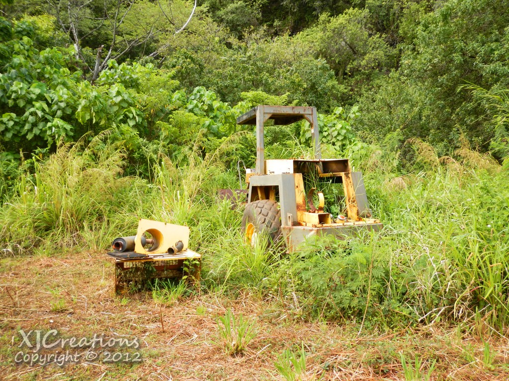
After passing this set of gates I continued down a long stretch contouring the ridge before passing the remains of an abandoned bulldozer.
Just beyond the curve I arrived at the first bridge.

The construction appeared to be from the the early part of the 1900's which made me start to wonder how old this road was because I hadn't researched the road's history before the hike.

Climbing up a small ridge I passed a solar powered station that looks like it's probably part of a stream gauge at a bend in the road.

The road dropped quickly into another valley and passed over another stream with a decent sized pool and a survey marker.


Again I climbed up the road out of the valley up to yet another ridge. By now I was wishing I had a bike, roller skates, a skateboard, or any other device with wheels to shorten this up! On the side of the road I spotted a fading sign which I assume is the mileage back to the start of the road in Helemano.

A short time later I arrived at yet another gate. What was surprising was the fact the road on the other side was paved like it is further up towards Kahuku.

The paved road continued to wind it's way through valleys and ridges passing an area where a more modern bridge had replaced an older one. It looked a lot like the one I'd seen in Kalihi Valley a few months back that dated back before 1930.

Around the next corner the road crossed another hill and then climbed up to an area below the wind farm being built in the upper areas of Kawailoa Road. A sign warned construction crews.


 | |
| Kawailoa Wind being built by First Wind |

To the north in the warning areas I could see the contrails of the F-22's doing maneuvers and to the west the occaisonal boom of artillery practice at Schofield.

 |
| Pa'ala'a Uka Road |
 |
| LeavingPa'ala'a Uka Road |
 |
| Guinea Grass. YUCK. |
 |
| Huge muddy pool with the frogs |

The old road/trail then rolled up and down the ridge line passing some Cook Pines as the ridge wandered a little to the right then straightened out with pines lining the ridge on both sides.
 |
| Veering right through the Cook Pines |
 |
 |
 |
| Last of the open trail... |

Worse yet the guinea grass showed up again. I hate that stuff with a passion. It's tiny fiber glass like hairs and razor sharp blades make uluhe look soft and cuddly!

My guess is that this remnant grass was brought up on the tires of vehicles from the fields below when the road was still in use. Several times it formed dense strands that I hacked away or bushwhacked around.
 |
| Halapepe a few feet off the right side of the trail |
 |
| Uluhe and Guniea grass combine to make my life miserable... |

Evaluating my options there was still plenty of time to turn around. I didn't know the exact mileage of the Kawailoa Trail but it was close to 6 miles each way and while initially I'd been making good time things were getting difficult fast. At 12:30 I had about 6 hours before the sun set and forward movement was at dismal speeds. It seemed prudent to add a decent buffer for times when I'd lose the trail so I set a turn around time of roughly half my sunlight at 3pm. I shouldered my pack again and continued to battle the uluhe up the trail.
 |
| Still walking along the old Army Rd |
 |
| Note the somewhat crazed look. The heat and Uluhe have combined forces and I've begun to loose it! |
 |
| Perhaps the end of the Army road |
 |
| An open section! |
 |
| Kawailoa Cabin - Circa 1960 - Photographer: Dick Davis, Source: Archives of Hawaiian Trail and Mountain Club, Curator/Scanner: Nate Yuen 2010 — at Oahu, Koolau Summit Trail, Northern Koolau Miountains. Used with permission. |
 |
| Kawailoa Trail... Finally! |
 |
| Nice big Koa! |
 |
| A nice open section |
 |
| Wild O'ahu |
 |
| This feels like the most remote part of O'ahu and if feels great to be here! |
Fighting my way further up the ridge I passed another Koa tree which had fallen over the trail which then vanished so I waded around in the uluhe and climbed up the ridge hoping to catch sight of some clue that would get be back on track.

Thrashing about I finally discovered the trail again which had contoured around the west side of the ridge and a short time later found the most welcome sight of the day- a clear stretch of trail.
Working my way along the contour things were really looking up. While still overgrown at least there was a path to follow. After about a quarter mile the trail crossed over to the east side of the ridge for about a tenth of a mile before switching back. I took a break to change the batteries out in my old Droid and then continued on. While the trail was clearer it still wasn't easy. Uluhe was sometimes at shoulder height along the way. By now I was rating anything below my waist as fantastic.

Latter I passed under a tunnel that had managed to stay clear since the trail was last used.

A huge fallen Ohia Tree.

An old metal pipe.

Finally some Austrailian Teas I'd read about showed up. Encouraging sign that at least I was getting closer to the upper reaches of the trail!
 |
| Australian Tea |
 |
| More uluhe... |
 |
| Washout |
Again the trail moved along the ridge towards the summit then hooked west around another small peak with another washout.
I passed another area of pua'a activity and spotted a large lobelia just off the trail. At times the trail was easy to find and clear, others scratchy and tough to discern from the pua'a highways.
 |
| Clermontia... probably C. persicifolia. |
 |
| One of many massive wallows |

In the upper sections of the trail conditions improved dramatically and I was able to pick up some speed as the sun dropped lower and lower off of Kaena Point. The evening lighting made for some gorgeous views.


At 6:36 I spotted some of the steel matting that had blown off the landing zone near the junction of the Ko'olau Summit Trail.

I breathed a sigh of relief now that I was on familiar ground as the sun sank into the water and the day quickly turned to night and the mists of the clouds rolled in. I sat down at where I believe the old cabin was on the summit next to an old rotted out canteen and caught my breath. The Kawailoa Trail had taken 7:42 total with lost time, pictures, ect and measured out at 5.85 miles from the junction with Paalaauka Rd. The worst of it had been fighting the uluhe in the lower and middle sections.
 |
| The Mt. Ka'ala long range radar lit up in the distance. |
 |
| A bit blurry but I liked the composition. The summit is amazing at night. |

I just happened to catch the broken summit sign as I passed by but would have realized it a few yards later anyway when the trail splits.

La'ie is one of my favorite trails and I've written enough about it already so I'll spare you the details of the descent. Familiar sites passed by the small area of illumination coming from my headlamp allowing me to roughly gauge my progress. I had called my wife and warned her that I would need a ride earlier and boy had I gotten an earful so I tried to time the pickup so I'd arrive first for sure. If she had to wait for me at the bottom the wrath would be exponential with each passing minute. When I got to the Cooke Pines that mark the bottom of the trail I very carefully chose my words in requesting that she please leave sometime soon and guaranteed that I would be ready when she arrived.
I stopped for a few moments to examine the spiders I kept seeing in the light from my headlamp. I'm no spider expert but I'd wager this is the wolf spider that carries it's young on it's abdomen until they are old enough to hunt for themselves. There is a species of wolf spider endemic to Hawaii, Lycosa hawaiiensis, but I have no idea if this one is a native or introduced species.
 |
| Wolf spider with keiki riding on her abdomen |

Cautiously, I approached the car. Covered in mud, uluhe debris, smelling pretty terrible, I made a quick assessment of the look on my wife's face and then the two sleeping keiki in the car seats. Yep, I was in a lot of trouble. I'd toyed with the idea of just taking the KST back down to Pupukea but it would have taken me all night to do and the trail gets a bit obscure at times making Laie the obvious choice. As I sat on the towel in the passenger's seat I was wondering if it might have been the better choice after all. It was a very long drive back to retrieve the Jeep as I got a stern looks and words from the Mrs. Picking up the Jeep we then retraced our way back to La'ie and then to Kailua. At about 11:20 we pulled back into the driveway. I emptied out the all the leaves and fern from my shoes and spent over a half hour in the shower scrubbing the mud off my battered legs. That summit mud never really washes all the way off no matter how hard you try!

Despite the length, difficulty, and the wrath of my wife I have to say it was totally worth the effort. I really enjoy the old CCC trails and I loved this one. This whole area of the Ko'olaus is basically cut off now and it's a real shame because it's amazingly beautiful. I neglected to take many shots of the scenery but there were several great views along the way.
I read somewhere that the army doesn't want this trail cleared because they're afraid the pua'a will use it to get to the summit. If that's true then I have bad news for the army. That trail is teaming with pigs. Hoof prints everywhere, massive wallows, and although overgrown by human standards it's completely clear by pig standards. They move effortlessly under the uluhe in tunnels and have torn up many areas especially where it's moist. I think they'd have far better results clearing the trail and encouraging hunting instead of leaving this part of the island to the pua'a.
This trail is old and traffic is nonexistent and I found cell service was poor at times too. The trail is closed, off limits, sometimes dangerous, and can be very difficult to follow. Proceed at your own risk!
More pictures from this trail and others I've done can be viewed on Flickr. Aloha and mahalo for reading.